My crocus and earliest daffodils are up and blooming. Fall-planted garlic and shallots are up and growing in the garden, and just received a top-dressing sprinkle of bonemeal and a light mulch of shredded leaves from last year. The soil in the rest of the Early garden bed has been composted and raked smooth, now being watered to bring up the weed seeds for a final cultivating before planting later this month. It's starting to look like Spring is on its way!
But there's still a lot of snow in the higher elevations, just 10 minutes drive away. And that means there's still a lot of snow fun - snowshoeing and cross-country skiing - to be enjoyed. When on an outing in the snow, it's important to have some kind of waterproof seating for lunch and break times; preferably lightweight, easy to fit in or strapped onto your daypack, and with a bit of insulating thickness to it. Harking back to my Girl Scout days, I decided to make a sit-upon.
For those of you who weren't Girl Scouts, making a sit-upon is a traditional camping project. They're made by weaving strips of newspaper into a padded square, then enclosing in an envelope of vinyl tablecloth or other waterproof fabric, to sit upon round the campfire. I decided to skip the waterproofing layer, and just make my woven pad out of waterproof material.
I have a few wintertime bird feeders hanging in a pine tree outside my picture window. I love watching the variety of birds in our area, so even though it's quite expensive these days I find buying birdseed a worthwhile expenditure. It now comes in woven plasticized bags, that I couldn't see just throwing away, so I've saved them in the bottom of the birdseed cans until now. They'd be perfect recycled into a woven sit-upon.
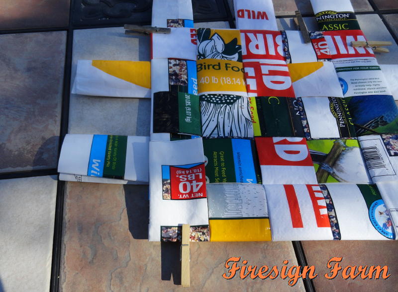
Working outside on the deck, to keep the little fluff bits of seed hulls out of the house, I cut the bags to open them out flat. With careful measuring, I could get three 12" x 25" sections from each 40-pound bag, or one plus a scant second one from the 20-pounders. By creasing each section lengthwise, opening it up and folding each long edge to the center crease, and then folding the center crease to enclose the cut ends (like bi-fold seam binding), I made 3" x 25" strips, each four layers thick with all cut edges enclosed, and clipped each one with a clothespin to keep them from blowing off my table.
Traditional GS sit-upons are 4 strips by 4 strips, making a 12" square that can be folded down to a 6" square. But my sit-upon-er is a bit bigger than a 10-year old girl's (besides, I'm also wearing multiple layers out in the cold) , so I made my sit-upon 5 strips by 5 strips - using 10 pieces total. Weave the strips together, trying to keep them pretty much centered in regards to the crosswise strips. They're a bit slippery, so I used the clothespins to keep them from sliding too far out of alignment while weaving them together.
Once all the strips are in place, more or less, start with the center and middle strips. Measuring to make sure they're centered, fold an end up over the edge of the cross-wise strip and tuck it snugly back underneath the strip you just folded it over. Spin the square around, push the strips together tight, and repeat on the other edge. When all of the bottom strips are folded up and tucked in, flip the pad over and do the same on the other side, all the while making sure all the strips are tucked up tight against each other.
For the corner strips, I folded them over but instead of tucking them back under the strip they'd just been folded over I tucked them under the edge of the next, adjacent, strip as I folded it up and tucked it in.
When all the strips are tucked in tight, you have a woven pad that holds itself together, and weighs practically nothing. I fold mine down into a 9"square and slide it down into my daypack between my water bladder sleeve and the rest of the pack contents. It works great! Snow gets into the weave if I spin around while sitting on it, but it's easy to shake out and wipe dry. I'm thinking this also will make a good garden kneeling pad, and probably make it into my summertime camping gear as well.
Showing posts with label outdoor recreation. Show all posts
Thursday, March 14, 2013
Friday, October 28, 2011
Bathtime for Boris; Monitor Pass Colors
It's that time of year. Boris, our German Shorthair pound hound, has been shedding quite a bit (and smelling rather doggy too). This morning, I decided it was bath day for Boris. I made a fire in the woodstove so it would be warm when we got out of the bathroom. Lots of treats, lots of towels to kneel on, and some tail-down shivering on his part (he's not a water dog), and I soon had a damp but sweet-smelling dog bouncing around the living room.
I wasn't done with those kneeling towels just yet. Of course, the bathtub then needed a good scrubbing. I soon had it shining once again. Since I was pretty much wet all down the front anyway, and had worked up a sweat scrubbing, I figured I needed a shower next (best way to make sure the tub was all rinsed down too).
Well, you can't have a clean dog sleeping in a grungy bed, can you? I bundled up all the mopping, sopping, and drying towels, along with his bed, and headed for the Laundromat. Some nice me-time for reading, and Boris soon had a fluffy clean bed.
Pictures of a wet dog or of a commercial washing machine tumbling round really aren't very interesting. So instead, I'm posting some photos from our day trip last week up Monitor Pass for some leaf-peeping. Boris loves when he gets to go places with us. He's such a great car dog, too. The truck has a little bench seat behind our seats. Boris sits behind Aries, so quietly (no panting, no pacing, just sits), and looks over Aries' shoulder or out his own little side window. With Aries off work until his hand heals, we're getting to do lots of the fall excursions we like but some years can't find the time. But with plenty of time this year, we timed it perfectly for the very peak of the show. It was a gorgeous day!
Aries' hand is doing pretty good. He got the stitches out a few days ago, and his splint reduced down to just his hand so he can now bend his wrist. He won't be released back to work until at least December. He got all his paperwork in for a Family Medical Leave of Absence (FMLA), and now we're in the 2-week waiting period before he starts getting temp-disability pay.
There's been a bit of adjustment to be made by both of us. Our grocery bill has gone up, since he's now eating breakfast and lunch at home instead of comp meals at work. But it's more than balanced out by the drop in the gas money, since he's not doing his 50-mile/day commute either. A happy re-discovery, a nice reminder, is just how much I really enjoy his company (after all, that is why I married him, 22 years ago this month). We each do have our own friends and things to do, but we're having fun spending lots of time together too.
For those of you reading this and thinking about a leaf-peeping outing this weekend: you may be a bit late for the high country this year. The past two nights, temperatures got down to 20F here at our house at 5,000'. A lot of our trees are now brown and the leaves are dropping. It's been dry, though, so you still could catch some good views. It would be perfect for the canyons and the California foothills though. Just don't wait much longer.
I wasn't done with those kneeling towels just yet. Of course, the bathtub then needed a good scrubbing. I soon had it shining once again. Since I was pretty much wet all down the front anyway, and had worked up a sweat scrubbing, I figured I needed a shower next (best way to make sure the tub was all rinsed down too).Thursday, August 26, 2010
Building a Hobart-Marlette Link Trail
Sunday, May 23, 2010
Just a Little Bit Crazy
Sometimes, doing crazy things makes me feel most alive. I went to two outdoor parties this weekend, and snowflakes were swirling on both. Now, it's supposed to be somewhat nice around here by the end of May, so the people that scheduled these parties weren't the crazy ones. It's all of us that showed up anyway :-)
Friday was the end of our local Bike to Work Week, with a big after-work party planned out on the open patio of a local establishment. I didn't ride my bicycle (my involvement with Muscle Powered leans more towards walking/hiking and advocacy), but I did bundle up to be there, and ended up manning the keg. The live entertainer played his instrument wearing fingerless biking gloves, and the attendees took turns around the outdoor firepit. We all laughed when Christy, wearing socks plus wool tights under her blue jeans, took off the socks to offer them to Terri, silly girl, who'd come from work wearing flip-flops. Terri immediately took her up on the offer, and donned said socks. Sometimes, a touch of insanity can really make the party. A good time was had by all.
And then, another party Saturday evening, also outdoors, also cold, windy, and snowing. This one was a neighborhood party, held at a sculpture shop down the street. The owner, and most of the guests, were Burning Man regulars, so I knew ahead of time that this party wouldn't be quite the usual fare. I've never been to Burning Man - my sister and I always plan our annual get-together at a Lake Tahoe beachfront campsite that week. Camping in a sandstorm in the desert with thousands, versus camping in the pines with family? No contest - I'll take the Lake. But the Burners are special and fun people, and so once again I bundled up and off we went. And again, another good time was had by all.
Friday was the end of our local Bike to Work Week, with a big after-work party planned out on the open patio of a local establishment. I didn't ride my bicycle (my involvement with Muscle Powered leans more towards walking/hiking and advocacy), but I did bundle up to be there, and ended up manning the keg. The live entertainer played his instrument wearing fingerless biking gloves, and the attendees took turns around the outdoor firepit. We all laughed when Christy, wearing socks plus wool tights under her blue jeans, took off the socks to offer them to Terri, silly girl, who'd come from work wearing flip-flops. Terri immediately took her up on the offer, and donned said socks. Sometimes, a touch of insanity can really make the party. A good time was had by all.
And then, another party Saturday evening, also outdoors, also cold, windy, and snowing. This one was a neighborhood party, held at a sculpture shop down the street. The owner, and most of the guests, were Burning Man regulars, so I knew ahead of time that this party wouldn't be quite the usual fare. I've never been to Burning Man - my sister and I always plan our annual get-together at a Lake Tahoe beachfront campsite that week. Camping in a sandstorm in the desert with thousands, versus camping in the pines with family? No contest - I'll take the Lake. But the Burners are special and fun people, and so once again I bundled up and off we went. And again, another good time was had by all.
Thursday, February 18, 2010
Magnificent Mountains, Blue Water
I work on-call in the tourism industry. Right now, with the economy the way it is, corporate tourism is way down so I haven't been working very much.
But when I do get called, it's always interesting, and sometimes downright fun. Yesterday evening, I got to shepherd a group for a Sunset Dinner/Dance Cruise on Lake Tahoe's MS Dixie II. The Dixie is one of three paddlewheelers on the Lake. We left from the dock on the east shore, the Nevada side of the Lake, crossed the south end of the Lake to the west shore, into and around Emerald Bay on the southwest corner, and back.
The Lake is 12 miles wide - it takes 3 hours to make this particular cruise. On the south shore, the lakeside casinos are on the Nevada side of the state line bisecting the lake. Heavenly Valley ski resort rises from a small base area just a few blocks away, on the California side, to an immense basin above, with a ridge straddling the state line between California and Nevada. Skiers can choose between the California runs overlooking the lake and the Nevada runs overlooking the sagebrush valley to the east. Freel Peak, at 10,891 ft, is the highest peak in the Tahoe Basin. Beyond Heavenly's base, it catches the last rays of the setting sun.
It was a beautiful evening - cold, of course, but no wind. The Lake was like glass. Lake level averages 6,225 feet above sea level, but can change daily depending on the weather. Tahoe ski resorts measure snowfall in feet, not inches. Mount Tallac dominates the view to the south, the only major peak to rise up right from the water's edge. (Clicking on any photo will bring up a bigger view)
The Lake is 22 miles long. It's hard to judge distance looking across water, especially in the thin, high mountain air, but those snow-covered mountains on the north shore are more than 20 miles away. The deepest part of the lake is off the north shore. At 1,645 ft deep, Tahoe is the second deepest lake in the U.S; the tenth deepest in the world. It never freezes, but never really warms up either.
The last photo I snapped, before completely losing the light, zooms in on Cave Rock, on the east shore. This large tan rock formation (also visible in the photo above this one), the core of an ancient volcano, is easily spotted from just about anywhere on the lake. The Washoe Indians, indigenous to the area, consider Cave Rock a sacred site - their ancestors used the original cave for religious ceremonies. Much to their dismay, a highway tunnel was blasted through the cave in the 1930's; a second bore added in the 1950's. They have succeeded however, in getting the Forest Service to declare the rock off-limits to climbers.
Dark comes early in the wintertime. Time to go inside for dinner. Afterwards, as we head back across the lake towards the dock, the stars are out, magnificent as well.
Tuesday, February 16, 2010
Laissez les bons temps rouler!
It's been more than 30 years since I got to see Mardi Gras in New Orleans. Many of my earlier adventures were cabin-fever relievers - excuses to get out of snow country, especially necessary by the time February rolls around. So I've seen Carnival celebrations a few other places as well, including the time I ended up dancing on a float in a parade in the Dominican Republic!
But money's tight these days. I haven't been able to go trotting about the globe for a few years now. Guess I'll just have to content myself with cranking up a Clifton Chenier CD and making Shrimp Creole for dinner instead.
I can't really complain though. The snow, at least here at the house, has melted and today was a beautiful day. I think I might even have gotten a bit of sunburn on my pasty white winter skin. We took the dog out for a few hours, across the valley, and hiked up and then along the ridge of Prison Hill. Sunshine, fresh air, a good workout with my sweetie - let the good times roll!
But money's tight these days. I haven't been able to go trotting about the globe for a few years now. Guess I'll just have to content myself with cranking up a Clifton Chenier CD and making Shrimp Creole for dinner instead.
Sunday, September 27, 2009
Another Big Weekend in N Nevada
After the Labor Day weekend, lots of our summer tourists head back home to get the kids back in school, not to be seen again until Christmas break skiing. This area really tries to lure them back in the meantime, with lots of big September events. It makes sense, really, September is usually a beautiful time of year around here, and this is an area that runs on tourist money.
The Fallon Air Show was back this year, at the Fallon Naval Air Station (ever see the movie Top Gun? that's what they do there. It's a realear buster window rattler WTF was that thrill driving out on Hwy 50 East across a deserted valley, and being buzzed by a trio of fighter jets). Then, there were the Reno Air Races, and the following weekend the Balloon Races in Reno and the Camel Races in Virginia City.
This weekend, I'm living with the almost constant roar of motorcycles on the highway two blocks below us, all day long and way into the night. It's Street Vibrations time in Reno - "a celebration of motorcycles, metal, and music." Of course, a celebration of motorcycles means they're on the move, up to Virginia City, around the lake, with events spilling over to every bike shop and dealership in the area. Our roads are clogged with long dual strings of motorcycles.
While the men are out on the roads, the women are heading to Genoa. The Candy Dance Arts & Crafts Faire this weekend draws thousands to check out the hundreds of craft booths. Normally, that's where I'd have spent my Saturday. It's been an annual tradition for some of my Lake Tahoe girlfriends to meet up there for lunch and browsing.
But noooo, not this year for me. My Soroptimist Club puts together a big fundraising golf tournament each year. Since most of the funds raised go to pay for mammograms (over $17,000 last year), we schedule the tournament for early October, Breast Cancer Awareness month. But by October, our weather can be iffy - very nice Indian Summer sometimes, or like last year, 40 mph winds blowing snow. So this year, we changed it to late September.
I took this photo the first year we held the tournament, nine years ago. And while it makes a very eye-catching photo, I was lobbying against the balloon release right from the start. Pretty flying balloons eventually pop, and become non-degradable, wildlife-threatening litter. I'm happy to say that, finally, this year there was no balloon release. We had the balloons tied to the carts and they stayed there while the golfers played, then were properly disposed of by the cart crew when the tournament was over.
I like being outside, so I usually volunteer to be a witness on one of the special par-3 holes where we have a prize (a car, a vacation cruise) for a hole-in-one. So this Saturday, from 9 a.m. until 2 p.m, I was sitting in a golf cart on Eagle Valley Golf's East Course hole #8. No hole-in-ones, although one group had a very nicely-played birdie. And instead of sitting wrapped up in a sleeping bag, I was glad I'd brought a blanket and clothespins to turn my cart into a little shade tent. It was downright HOT!! with temperatures in the upper-80's by the time I got to come in. And now, that's one more thing I get to cross off my crowded September list of things to do.
The Fallon Air Show was back this year, at the Fallon Naval Air Station (ever see the movie Top Gun? that's what they do there. It's a real
This weekend, I'm living with the almost constant roar of motorcycles on the highway two blocks below us, all day long and way into the night. It's Street Vibrations time in Reno - "a celebration of motorcycles, metal, and music." Of course, a celebration of motorcycles means they're on the move, up to Virginia City, around the lake, with events spilling over to every bike shop and dealership in the area. Our roads are clogged with long dual strings of motorcycles.
While the men are out on the roads, the women are heading to Genoa. The Candy Dance Arts & Crafts Faire this weekend draws thousands to check out the hundreds of craft booths. Normally, that's where I'd have spent my Saturday. It's been an annual tradition for some of my Lake Tahoe girlfriends to meet up there for lunch and browsing.
But noooo, not this year for me. My Soroptimist Club puts together a big fundraising golf tournament each year. Since most of the funds raised go to pay for mammograms (over $17,000 last year), we schedule the tournament for early October, Breast Cancer Awareness month. But by October, our weather can be iffy - very nice Indian Summer sometimes, or like last year, 40 mph winds blowing snow. So this year, we changed it to late September.
I took this photo the first year we held the tournament, nine years ago. And while it makes a very eye-catching photo, I was lobbying against the balloon release right from the start. Pretty flying balloons eventually pop, and become non-degradable, wildlife-threatening litter. I'm happy to say that, finally, this year there was no balloon release. We had the balloons tied to the carts and they stayed there while the golfers played, then were properly disposed of by the cart crew when the tournament was over. I like being outside, so I usually volunteer to be a witness on one of the special par-3 holes where we have a prize (a car, a vacation cruise) for a hole-in-one. So this Saturday, from 9 a.m. until 2 p.m, I was sitting in a golf cart on Eagle Valley Golf's East Course hole #8. No hole-in-ones, although one group had a very nicely-played birdie. And instead of sitting wrapped up in a sleeping bag, I was glad I'd brought a blanket and clothespins to turn my cart into a little shade tent. It was downright HOT!! with temperatures in the upper-80's by the time I got to come in. And now, that's one more thing I get to cross off my crowded September list of things to do.
Wednesday, April 22, 2009
Echo Summit and a Birthday Party
We took off for a couple of days to visit some of Aries' relatives near Sacramento. This trip, we took Highway 50 over the Sierras. First, we drove up out of our valley, over Spooner Summit and then down to and around the south end of Lake Tahoe.
Tahoe is said to be a Washoe Indian word, meaning Big Sky Water, and scenes like this make it easy to see why they named it that. The natural lake, more than 6,000 feet above sea level is so deep that it never freezes, and almost always reflects the color of the sky.
Once around the lake, we start to climb up out of the Tahoe Basin over Echo Summit. This narrow mountain road is one of the major routes between the Lake and California. The snow is finally starting to melt from the hillsides above, sending rivulets of water cascading down next to the road. The granite rises straight above the road on one side, and drops more than 1000 feet on the other; rooftops and trees dot the valley far below.
Dropping down the western slope, Desolation Wilderness is north of the highway. Despite the name, this wilderness area is one of the most accessible in California. It is 100 square miles of glaciated granite, dotted with many small lakes. Above the Twin Bridges trailhead, a quick glimpse of Horsetail Falls (in the middle of the photo, right below the saddle) shows quite a bit of water coming down. During the winter, the falls are sparkling white, blue and green ice; by September the water will slow to a trickle sliding down the rock face.
As the highway drops lower in altitude the snowbanks get smaller and smaller. By the time we've dropped down into the American River canyon, they're gone completely. As we continue westward, Springtime advances and by the time we reach the Apple Hill area above Placerville the trees are in full bloom; the Sierras just a snowy line on the eastern horizon.
We had a nice visit. One of Aries' cousins hosted a barbecue for her dad's 85th birthday. The brother of Aries' dad, his uncle is the only one of that generation left on either side of Aries' family. His other cousin flew in from Salt Lake City for the party, so it made for a nice reunion. While Aries and I had visited his uncle and aunt before, I'd never met these cousins. They're all great people and we had a wonderful time.
It was sooooo hot and humid down there though. After a couple of days, I'm so glad to get back to my cool and dry desert. I can wait a bit longer for summer to arrive, thank you.
Once around the lake, we start to climb up out of the Tahoe Basin over Echo Summit. This narrow mountain road is one of the major routes between the Lake and California. The snow is finally starting to melt from the hillsides above, sending rivulets of water cascading down next to the road. The granite rises straight above the road on one side, and drops more than 1000 feet on the other; rooftops and trees dot the valley far below.
Dropping down the western slope, Desolation Wilderness is north of the highway. Despite the name, this wilderness area is one of the most accessible in California. It is 100 square miles of glaciated granite, dotted with many small lakes. Above the Twin Bridges trailhead, a quick glimpse of Horsetail Falls (in the middle of the photo, right below the saddle) shows quite a bit of water coming down. During the winter, the falls are sparkling white, blue and green ice; by September the water will slow to a trickle sliding down the rock face.Wednesday, March 25, 2009
Ash Canyon
It was a bit chilly but the sun was shining, so I got out for a walk with a couple of friends yesterday. We met on the edge of a subdivision on the west side of town, to hike a mile or two up Ash Canyon.
We parked next to a couple of city water tanks and walked up the dirt road heading up the canyon. Behind us, the silver dome of the capitol building in the center of town glints in the rays of the afternoon sun. This area burned in a wildfire four and a half years ago - the lower hills are covered with last year's dry grass and weeds; the sagebrush still small, just starting to grow back.
Just over the first rise, we left the road to take a small dirt trail down to the creek. Snow still lingered on the north-facing sides of the canyon, but had melted away on the south-facing sides. The creek sparkles in the sun shining down through the leafless trees. The water was icy cold - in fact, icicles still hung where water had splashed up and froze the night before.
It's been five years since the Waterfall fire burned through this area. The underbrush next to the creek has come back. But many of the big pines and cottonwood trees are gone - only skeletons standing against the sky.
We could see the tracks of mountain bicycles on the damp trail. It's still a beautiful place, close to town, to hike or bike. In the black and white of the winter landscape, the black peeling bark, the bleached dead wood and the charred interior of a burned poplar tree becomes nature's work of art.
There are signs that Spring is coming. Small plants and grasses sprout in the damp soil. In sunny places alongside the creek, we stop to stroke the fuzzy little catkins on the willows.
We see an odd pile of rocks, a small branch sticking up out of the center. Upon closer examination, we see there's carving on the stick, and realize it's a grave. "Hear [sic] lies the stinky dog RIP," it says.
The trail crosses the creek, and meanders along the shady north side for a while. It's colder on that side, but the effort of the uphill climb keeps us from getting cold. Another bridge brings us back to the sunnier side. We're warmed up enough now to take off our top sweatshirt layers and tie them about our waists.
We stop often just to listen to the sound of the creek as it tumbles down the bottom of the little canyon. It's obvious that someone else comes here for the same reason when we come upon a little rock chair, just big enough for one person to sit and meditate on the sound of the water below.
As we follow the creek uphill, the canyon gets narrower and the walls steeper. The trail climbs farther above the creek. Finally, we come to where the trail switchbacks up, away from the creek, to meet the dirt road above. We decide we'd rather return the way we came, so turn around and retrace our steps alongside the creek. Such a wonderful outing, right on the edge of town.
Sunday, March 1, 2009
Looking for Eagles
It's a grey day, and looks like it's snowing in the Sierras already. But the storms hadn't come over the mountains yet this morning, so we took a little Sunday drive to look for eagles.
As bald eagles start their spring migrations to the Pacific Northwest, many stop off here for a snack. Just over the ridge to the south, the Carson Valley is still home to quite a few cattle ranches (Carson City is in the more urbanized Eagle Valley - confusing to newcomers). The end of February is calving time at the cattle ranches. Eagles can often be seen out walking around in the cow pastures, looking for the afterbirth - evidently an eagle's idea of a tasty treat.
Some of the ranchers move their pregnant herds into pastures close to the roads, giving folks around here a better chance at spotting an eagle. Others have joined together to provide tours of their ranches and barn areas, educating the public about eagle habitat preservation in the process. We didn't spot any eagles this morning. Many cows have already had their calves, so we might have been a week too late, but I'll still keep an eye out whenever I'm out and about - the weather will probably keep the birds around for a couple more weeks. It's really a thrill to see one perched on a neighborhood telephone pole.
Wednesday, January 21, 2009
Reno-Tahoe in Winter
Joy, from Perth, Australia, wrote that her youngest son and grandson, both in their 20's, were coming this way and asked what there was to do and see. Oh boy - where do I start? First, let me be clear that this the Reno/Tahoe part of Nevada. It's up where the eastern edge of California makes that angled bend. Las Vegas, despite being in the same state, is nowhere near here. Vegas is a good 7-8 hours drive south of here, a completely different climate and environment.
The jewel of the area is Lake Tahoe itself - a natural alpine lake more than 6,000 ft above sea level, completely ringed by mountains rising even higher. The lake is half in California, half in Nevada - the angled bend in the state line, mentioned above, is out in the middle. The lake reflects the sky and, with our annual average of 300 sunny days, is almost always a beautiful blue. More than 1,600 feet deep, it never freezes. Twelve by twenty-two miles, it has more than 70 miles of shoreline. Driving around the lake can make for a wonderful day. It takes about 3 hours to drive it straight through, but allow much more time to stop and gawk. Every turn brings a new vista and there are plenty of spots to pull over to take photos, plenty of interesting places to stop and shop or to grab some lunch or a cup of coffee.
If limited in time, at least try to make it out to Emerald Bay. Said to be one of the most photographed spots in the world, it's well worth the drive, especially if you're staying on the south shore. On top of little Fanette Island are the ruins of a stone teahouse, part of the Vikingsholm estate built in the 1920's. The estate, now owned by California, includes a "castle" at the end of the bay, open for tours in the summer. Check first to make sure the road around Emerald Bay is open - that part is occasionally closed for avalanche control. And take care - the road is narrow and twisty, and shady spots can be icy even when the rest of the road is dry.
If you'd like to see the lake from the water, there are Mississippi paddlewheelers that cruise from South Lake Tahoe, and Zephyr Cove on the east shore, across the lake to Emerald Bay and back. In winter, there are scenic cruises daily, and sunset dinner cruises Wednesdays and Saturdays. On some winter Fridays, the Ski Cruise sounds like a great time - take a ski bus from your South Shore hotel to the Squaw Valley Village to spend the day, and then party on the return trip across the lake on the paddlewheeler.
Of course, the main reason people come to this area in the winter is to play in the snow. Tahoe offers something for everyone, from downhill skiing and boarding, to cross-country and snowshoeing, to ice skating, sledding and tubing (sliding down the hill on an inflated tire innertube). The area has the largest concentration of ski resorts in North America, and they measure snowfall in feet instead of mere inches. Every place has some kind of lesson package, and rental equipment is readily available. At Heavenly Valley, on the south shore, some ski runs face the whites and blues of the Tahoe Basin, others overlook the tans and greys of the high-desert Carson Valley. A few miles west of Tahoe City on the west shore, Squaw Valley was the site of the 1960 Winter Olympics. Both those big resorts offer gondola rides to the top of the mountain for non-skiers, and numerous other activities as well.
A few miles further west of Squaw, you'll come to Truckee, an interesting little old-west railroad town where Amtrak's California Zephyr stills stops daily on its route between Chicago and the San Francisco Bay. Just west of Truckee is a California State Park memorializing the tragic Donner Party pioneer wagon train. The museum is open year-round, and there are winter trails for cross-country skiers and snowshoers.
Reno is 30 minutes drive east of Truckee on I-80. In between, at the bottom of the pass at Boomtown, is a Cabela's sporting goods store. It's worth a visit, not necessarily to buy anything, but just to wander around and look. The store is a natural history museum of sorts, with taxidermy displays and dioramas from around the world and a couple of huge aquariums. I know it's strange to recommend stores as must-see items on a tourist listing, but Scheels on I-80 just east of Reno in Sparks is another amazingly massive sporting goods store experience. Both stores will provide lots of low-cost entertainment, inside out of the cold.
Reno has numerous attractions, aside from casinos, where you can get out of the cold too. The boys might enjoy wandering through the National Auto Museum, watching college basketball at the Lawlor Events Center, or checking out what's happening at the Reno Events Center - all within walking distance downtown. The big casinos, both in Reno and Tahoe's south shore, also offer a variety of shows and nightclubs - pick up a local newspaper to see who and what is playing where.
Of course, boys in their 20's might prefer checking out the coeds and the bars around the University of Nevada, Reno campus, also walking distance from downtown, just north of I-80 off Virginia Street. UNR is Nevada's land-grant institution - the buildings date from 1887 to the present. The Student Union or Main Library could be good places for some downtime and computer access.
The eastern side of the Sierra Nevada mountain range is still seismically active, and contains many natural hot springs - a good way to warm up after a cold day skiing. Many are open to the public, with amenities such as the individual baths at Steamboat south of Reno, an outdoor pool at Carson in Carson City, and the full spa treatments at Walley's just south of Genoa, Nevada's oldest settlement.
Carson City, 25 miles south of Reno, is the capital of Nevada. The silver-domed capitol building is open to the public, with interesting displays on both floors. The State Museum is just down the street in the old US Mint Building, with everything from the original coin press to fossils to a walk-through replica of an underground mine. On the south end of town, there's the Railroad Museum and the local Visitors' Center. I haven't been in there lately, but they used to have a great aerial photograph on the wall, showing Carson City in the foreground, the Carson Range to the west, and beyond that Lake Tahoe - with the water level obviously 1,500 feet above the town.
East of Carson City, just off Highway 50, are some local businesses the Visitors' Center might not mention - the bunny ranches (and I don't mean rabbits). Brothels are legal in the rural counties of Nevada, and the county line is right on top of the hill. A couple of blocks off the highway to the north is the Moonlite Ranch, probably best known as the location for the HBO series, Cathouse; to the south are the Sagebrush, Kit Kat, and Moonlite II (formerly Kitty's). Some of the girls used to stop in at the bar where I worked on their way back to their week on-duty at the "ranches", and told me a bit about their job - they are examined by a doctor and tested for various diseases weekly; the men must always use condoms (per state law); no licensed prostitute in Nevada has ever tested positive for HIV/AIDS; and the girls also get a three-day class on detecting signs of STDs in men before they go into the line-up. Everything else, so I hear, is negotiable.
A couple of miles further east is the turnoff to Virginia City. No matter where my travels have taken me in the world, even places where people don't speak English, I can always get across where I'm from by humming the theme song from Bonanza - everybody knows that music and the burning map! While the Cartwrights never really walked the streets of Virginia City, a young man named Samuel Clemens did. Later, using the pen name Mark Twain, he wrote Roughing It, a great account of his adventures in the area. The gold and silver from the mines of the Comstock Lode helped finance the Union Army in the Civil War, and played a key part in the growth of San Francisco, California. The town is the largest designated Historical District in America, with the main street pretty much the same as it was in the 1860's. You can spend a fun day walking the board sidewalks, checking out the little shops and old saloons, maybe wandering through the old cemeteries on the northeast end of town, or taking in a museum or a tour. You might even want to take a ride on the tourist railroad running on the old Virgina & Truckee (V&T) route - the "crookedest short line in the world". Work is in progress to eventually rebuild the tracks all the way back to Carson City someday. It gets really cold up there once the sun sets in the winter, and the town pretty much rolls up its sidewalks then - time to head back down the mountain.
Of course, there are always the casinos. Nevada bars and casinos never close - they're open 24/7. You must be 21, and if you look young probably will be carded - carry proof-of-age identification. Many of the bigger casinos offer lessons in how to play the various games, and just about all have a Sports Book, where you can place a bet on just about any sports-related event in the country (you can even wager on whether the Super Bowl coin toss will be heads or tails). Oh, by the way, it's not called gambling here - "gambling" represents risk; the casinos prefer the term "gaming" - gaming denotes entertainment and fun. It's just Nevada semantics - decide your monetary limits before you start, and don't let the free drinks cloud your judgement. If you're playing, tipping the cocktail waitress increases the likelihood that she'll come around often, and if you're winning, the dealers appreciate the occasional tip as well. Be forewarned - altitude exaggerates the effects of alcohol.
I'm sure that's plenty of things to think about, if you've read this far. If you're driving across the Sierras, check weather and road conditions before you start. Many of the Sierra crossings farther south close for the winter; winter storms and avalanches can close the ones around here temporarily. Carry tire chains, and be prepared for winter driving conditions. Drink plenty of water to alleviate the headaches and possible nausea the altitude can induce - you should adjust after a couple of days. My email address is over there in the sidebar if you have specific questions and would like to reach me directly. I'll try to do a summer-specific post later in the year. Enjoy your visit!
The jewel of the area is Lake Tahoe itself - a natural alpine lake more than 6,000 ft above sea level, completely ringed by mountains rising even higher. The lake is half in California, half in Nevada - the angled bend in the state line, mentioned above, is out in the middle. The lake reflects the sky and, with our annual average of 300 sunny days, is almost always a beautiful blue. More than 1,600 feet deep, it never freezes. Twelve by twenty-two miles, it has more than 70 miles of shoreline. Driving around the lake can make for a wonderful day. It takes about 3 hours to drive it straight through, but allow much more time to stop and gawk. Every turn brings a new vista and there are plenty of spots to pull over to take photos, plenty of interesting places to stop and shop or to grab some lunch or a cup of coffee.If you'd like to see the lake from the water, there are Mississippi paddlewheelers that cruise from South Lake Tahoe, and Zephyr Cove on the east shore, across the lake to Emerald Bay and back. In winter, there are scenic cruises daily, and sunset dinner cruises Wednesdays and Saturdays. On some winter Fridays, the Ski Cruise sounds like a great time - take a ski bus from your South Shore hotel to the Squaw Valley Village to spend the day, and then party on the return trip across the lake on the paddlewheeler.
Of course, the main reason people come to this area in the winter is to play in the snow. Tahoe offers something for everyone, from downhill skiing and boarding, to cross-country and snowshoeing, to ice skating, sledding and tubing (sliding down the hill on an inflated tire innertube). The area has the largest concentration of ski resorts in North America, and they measure snowfall in feet instead of mere inches. Every place has some kind of lesson package, and rental equipment is readily available. At Heavenly Valley, on the south shore, some ski runs face the whites and blues of the Tahoe Basin, others overlook the tans and greys of the high-desert Carson Valley. A few miles west of Tahoe City on the west shore, Squaw Valley was the site of the 1960 Winter Olympics. Both those big resorts offer gondola rides to the top of the mountain for non-skiers, and numerous other activities as well.A few miles further west of Squaw, you'll come to Truckee, an interesting little old-west railroad town where Amtrak's California Zephyr stills stops daily on its route between Chicago and the San Francisco Bay. Just west of Truckee is a California State Park memorializing the tragic Donner Party pioneer wagon train. The museum is open year-round, and there are winter trails for cross-country skiers and snowshoers.
Reno is 30 minutes drive east of Truckee on I-80. In between, at the bottom of the pass at Boomtown, is a Cabela's sporting goods store. It's worth a visit, not necessarily to buy anything, but just to wander around and look. The store is a natural history museum of sorts, with taxidermy displays and dioramas from around the world and a couple of huge aquariums. I know it's strange to recommend stores as must-see items on a tourist listing, but Scheels on I-80 just east of Reno in Sparks is another amazingly massive sporting goods store experience. Both stores will provide lots of low-cost entertainment, inside out of the cold.
Reno has numerous attractions, aside from casinos, where you can get out of the cold too. The boys might enjoy wandering through the National Auto Museum, watching college basketball at the Lawlor Events Center, or checking out what's happening at the Reno Events Center - all within walking distance downtown. The big casinos, both in Reno and Tahoe's south shore, also offer a variety of shows and nightclubs - pick up a local newspaper to see who and what is playing where.
Of course, boys in their 20's might prefer checking out the coeds and the bars around the University of Nevada, Reno campus, also walking distance from downtown, just north of I-80 off Virginia Street. UNR is Nevada's land-grant institution - the buildings date from 1887 to the present. The Student Union or Main Library could be good places for some downtime and computer access.
The eastern side of the Sierra Nevada mountain range is still seismically active, and contains many natural hot springs - a good way to warm up after a cold day skiing. Many are open to the public, with amenities such as the individual baths at Steamboat south of Reno, an outdoor pool at Carson in Carson City, and the full spa treatments at Walley's just south of Genoa, Nevada's oldest settlement.
Carson City, 25 miles south of Reno, is the capital of Nevada. The silver-domed capitol building is open to the public, with interesting displays on both floors. The State Museum is just down the street in the old US Mint Building, with everything from the original coin press to fossils to a walk-through replica of an underground mine. On the south end of town, there's the Railroad Museum and the local Visitors' Center. I haven't been in there lately, but they used to have a great aerial photograph on the wall, showing Carson City in the foreground, the Carson Range to the west, and beyond that Lake Tahoe - with the water level obviously 1,500 feet above the town.East of Carson City, just off Highway 50, are some local businesses the Visitors' Center might not mention - the bunny ranches (and I don't mean rabbits). Brothels are legal in the rural counties of Nevada, and the county line is right on top of the hill. A couple of blocks off the highway to the north is the Moonlite Ranch, probably best known as the location for the HBO series, Cathouse; to the south are the Sagebrush, Kit Kat, and Moonlite II (formerly Kitty's). Some of the girls used to stop in at the bar where I worked on their way back to their week on-duty at the "ranches", and told me a bit about their job - they are examined by a doctor and tested for various diseases weekly; the men must always use condoms (per state law); no licensed prostitute in Nevada has ever tested positive for HIV/AIDS; and the girls also get a three-day class on detecting signs of STDs in men before they go into the line-up. Everything else, so I hear, is negotiable.
A couple of miles further east is the turnoff to Virginia City. No matter where my travels have taken me in the world, even places where people don't speak English, I can always get across where I'm from by humming the theme song from Bonanza - everybody knows that music and the burning map! While the Cartwrights never really walked the streets of Virginia City, a young man named Samuel Clemens did. Later, using the pen name Mark Twain, he wrote Roughing It, a great account of his adventures in the area. The gold and silver from the mines of the Comstock Lode helped finance the Union Army in the Civil War, and played a key part in the growth of San Francisco, California. The town is the largest designated Historical District in America, with the main street pretty much the same as it was in the 1860's. You can spend a fun day walking the board sidewalks, checking out the little shops and old saloons, maybe wandering through the old cemeteries on the northeast end of town, or taking in a museum or a tour. You might even want to take a ride on the tourist railroad running on the old Virgina & Truckee (V&T) route - the "crookedest short line in the world". Work is in progress to eventually rebuild the tracks all the way back to Carson City someday. It gets really cold up there once the sun sets in the winter, and the town pretty much rolls up its sidewalks then - time to head back down the mountain.Of course, there are always the casinos. Nevada bars and casinos never close - they're open 24/7. You must be 21, and if you look young probably will be carded - carry proof-of-age identification. Many of the bigger casinos offer lessons in how to play the various games, and just about all have a Sports Book, where you can place a bet on just about any sports-related event in the country (you can even wager on whether the Super Bowl coin toss will be heads or tails). Oh, by the way, it's not called gambling here - "gambling" represents risk; the casinos prefer the term "gaming" - gaming denotes entertainment and fun. It's just Nevada semantics - decide your monetary limits before you start, and don't let the free drinks cloud your judgement. If you're playing, tipping the cocktail waitress increases the likelihood that she'll come around often, and if you're winning, the dealers appreciate the occasional tip as well. Be forewarned - altitude exaggerates the effects of alcohol.
Monday, December 8, 2008
Canning Salmon
I love salmon. When I get the chance to go out to dinner at a really nice place, odds are I'll order the salmon. Even though I've never lived near an ocean, I've caught and canned my share of salmon. Sockeye salmon, the pink-fleshed tasty kind, spawn and live for a while in fresh water before heading downstream to the sea. But there's also a landlocked variety of sockeye that lives its entire life in fresh water, called kokanee salmon. When I lived in Leadville, I'd try to make it out to my favorite spot on the river in the fall, just before it entered a big mountain reservoir, for salmon snagging (Colorado has a legal snagging season in the fall - the mature salmon heading upstream to spawn aren't interested in hitting a lure, but you can snag them with big weighted treble hooks using a jerk-n-reel tactic. They're going to die anyway, and it's food in the pantry).
My dad loved fishing. Every summer, my folks would camp at mountain reservoirs, taking the boat out all day, rigged for salmon fishing. Mom would take the pressure cooker and jars along, and after a couple of days of fishing success would can the salmon right there at their campsite. Since moving to Nevada, I'd always beg them to bring me jars of salmon when they were coming out to visit. But, while writing my last post, I realized that with the passing of my dad earlier this year, those jars of salmon might not be quite so plentiful now.
My Colorado brother has dad's boat now, he likes to fish, and probably even cans his salmon. But I don't see him very often. My Colorado sister and her husband also have a boat, fish for salmon, and might have to start canning their own catch (Mom might still do it for them - they live close by). So I still might be able to beg jars from family on occasion. But then again, Lake Tahoe, right over the hill, has kokanee in it. I might have to start looking around for someone with a boat, and start canning my own salmon again. When I asked Aries to ask his co-workers about who goes fishing, he said one guy had mentioned maybe trading fresh salmon for our eggs. That would work. Or maybe I can find someone that would trade salmon for my canning efforts - we could split the results (especially if I could get them to return the empty jars for "re-filling"). I'll have to look into that. If you do have access to fresh salmon, whether from salt- or fresh-water, and a pressure cooker or canner, salmon are easy to can.
Canning Salmon
Kokanee aren't as big as ocean salmon, so they're usually canned cut in cross-wise chunks, skin-on, instead of filleted. Gut the fish, and cut off the head and tail. Remove loose scales and clean the skin by scraping. Cut away the flabby belly flap and the fins (cutting down into the flesh to get the fin bones too). Cut crosswise in lengths to fit your jar leaving at least ½" headspace. Pack into sterilized pint jars - straight-sided wide-mouth jars work best. Add 1 teaspoon vinegar to each jar, seal, and process at 10 pounds pressure for 90 minutes.
Salmon creates its own juices during the canning process. Leaving the skin on means more of the Omega 3 oil that makes eating salmon so good for you. The vinegar softens the little bones so that they just disappear. When I use a jar of salmon, I'll drain off the liquid, pull off the skin, and pick out the big backbone sections. Then I'm ready to make salmon patties, dip, pasta salads, all kinds of good eats.
My Colorado brother has dad's boat now, he likes to fish, and probably even cans his salmon. But I don't see him very often. My Colorado sister and her husband also have a boat, fish for salmon, and might have to start canning their own catch (Mom might still do it for them - they live close by). So I still might be able to beg jars from family on occasion. But then again, Lake Tahoe, right over the hill, has kokanee in it. I might have to start looking around for someone with a boat, and start canning my own salmon again. When I asked Aries to ask his co-workers about who goes fishing, he said one guy had mentioned maybe trading fresh salmon for our eggs. That would work. Or maybe I can find someone that would trade salmon for my canning efforts - we could split the results (especially if I could get them to return the empty jars for "re-filling"). I'll have to look into that. If you do have access to fresh salmon, whether from salt- or fresh-water, and a pressure cooker or canner, salmon are easy to can.
Canning Salmon
Kokanee aren't as big as ocean salmon, so they're usually canned cut in cross-wise chunks, skin-on, instead of filleted. Gut the fish, and cut off the head and tail. Remove loose scales and clean the skin by scraping. Cut away the flabby belly flap and the fins (cutting down into the flesh to get the fin bones too). Cut crosswise in lengths to fit your jar leaving at least ½" headspace. Pack into sterilized pint jars - straight-sided wide-mouth jars work best. Add 1 teaspoon vinegar to each jar, seal, and process at 10 pounds pressure for 90 minutes.
Salmon creates its own juices during the canning process. Leaving the skin on means more of the Omega 3 oil that makes eating salmon so good for you. The vinegar softens the little bones so that they just disappear. When I use a jar of salmon, I'll drain off the liquid, pull off the skin, and pick out the big backbone sections. Then I'm ready to make salmon patties, dip, pasta salads, all kinds of good eats.
Monday, October 20, 2008
Monitor Pass
Aries is on vacation for two weeks. He always takes vacation time in October, ever since our honeymoon (it was our 19th anniversary, earlier this month). We usually get a hard freeze by mid-October, so he helps clean up the garden for the season, makes compost, and does all the household maintenance chores before winter sets in - clean the chimney, roof and gutter repairs, vehicle maintenance, drain the irrigation system, lots of little honey-do's. But we also make time for little daytrip outings too. Autumn is such a nice time of year here. The nights are chilly, but the days quite often are blue skies and moderate temperatures.
A couple of days ago, we decided to take a drive over Monitor Pass. We headed south out of town, crossing the California state line in the Carson Valley, through the little hamlet of Woodfords, and continued south through the tiny town of Markleeville. We continued south along the east fork of the Carson River, where the cottonwoods and willows were just starting to turn to gold. We left the river and turned east, climbing up over Monitor Pass.
Monitor Pass is one of the higher passes in the area, at 8,300 feet, and usually closed November to April by snow. On top is a big grove of aspen trees, that can be stunning this time of year. We turned off the paved road and drove up into the aspen grove. Unfortunately, a dry winter last year, and an early snow this year, left the colors dulled and some of the leaves already down. But it was a nice day to get out, let the dog run, and wander about the grove, crunching over the snow still lingering in the shady spots.
Basque sheepherders have been scratching and carving the smooth white bark of aspen trees in the West since the 1860's. Many of the carvings are names and dates - an "I was here" marking. Some are a bit more artistic - perhaps the shape or face of a loved one back home. Still others are even more graphic about what was on these lonely shepherds' minds - some to the point of being considered pornography. I'll only post some of the more G-rated ones here.


After a while, we get back in the truck and start down the eastern side of the Pass. As the road switchbacks down, the change in vegetation, from the evergreen forests of the Sierra to the piƱon pines and chaparral of the Great Basin, is obvious. The Great Basin is the high-desert between the Sierra Nevada and the Rocky Mountains. This vast area isn't flat - it's wrinkled and rippled, like the inside part of a sheet of corrugated cardboard, range after mountain range alternating with little valleys across all of Nevada and most of Utah.
It's called a Basin because none of the water flowing here ever reaches an ocean - the snow melts into rivers that either just disappear into the sand, or flow into lakes, like the Great Salt Lake, and are lost to evaporation. At the bottom of the pass, we turn north, crossing the state line back into Nevada at Topaz Lake, and a 45-minute drive back home. (The two photos directly above almost fit together as a panorama - the dark hill in the middle distance on the extreme right of the lower photo is the same one on the left side of the upper photo; the snow-covered peaks, right side of the upper photo are the Sierra Nevada range in California, the ones in the lower photo are looking east across two smaller Nevada ranges.)
Subscribe to:
Posts (Atom)